The Samoeng Loop is a roughly 100-kilometer mountain circuit northwest of Chiang Mai, and for most riders on most days it works best ridden counterclockwise. That direction sends you up Mae Sa Valley first, past the waterfalls and the botanical garden while you are fresh, and saves Route 1269 (the steep, technical southern return) for the end, after easier kilometers have let you settle into the brakes, the tyres, and the way the bike turns. Clockwise reverses that, putting the hardest road first, before you have any feel for it. Counterclockwise is the better default, but it depends on an early start: leave late and the same order pushes Route 1269 into low light and tired arms.
The loop is three different roads that happen to form a circuit, and the order you face them changes the whole day. It decides whether you reach Mae Sa Waterfall before it closes at 16:30, how much energy is left when the switchbacks demand full attention, and whether the mountain views are ahead of you or already behind. None of that is hard to manage, but it does not manage itself. The riders who have a bad day on the Samoeng Loop almost always started late, ran out of light, or arrived in the wrong season.
A full loop with the three main stops done properly is a full day. Start by 8:00, fill the tank before you leave the valley floor, and check the calendar and the season: the Queen Sirikit Botanical Garden itself is open daily, though its Natural History Museum section closes on Mondays, and from late February through April smoke usually flattens the long mountain views. If you are short on time, Mae Sa Valley as an out-and-back is a good half-day alternative. If you are not already comfortable riding in traffic and on hills, the answer is different: this is not a route to learn on, and going by car, with a driver, or as a passenger is the sensible choice.
This guide follows the route in order, from Chiang Mai through Mae Sa Valley, Mon Jam, the quiet forest road to Samoeng, Route 1269, and back into the city, with the timing, fuel, season, and stop-by-stop detail you need to plan your own day.
Contents
show

Quick Facts
- Distance: approximately 100 km round trip from Chiang Mai
- Time needed: a full day for the complete loop with the three main stops; half a day for a Mae Sa Valley out-and-back
- Default direction: counterclockwise for most riders, provided you start early
- Start time: 8:00 ideal, 9:00 at the latest
- Hardest section: Route 1269 southern return (steep switchbacks in the Mae Khanin / Ban Mae Khanin area)
- Skill needed for the full loop: comfortable with downhill braking, tight switchbacks, and uneven surfaces
- Best season: November to mid-February
- Poor for mountain views: late February to April (smoke haze)
- Open daily: Queen Sirikit Botanical Garden (only its Natural History Museum section closes Mondays)
- Fuel: fill up before Mae Rim; fuel options after Pong Yang are limited and should not be part of your plan
Counterclockwise Is the Better Default for Most Riders
Counterclockwise is the right direction for most people on most days, because it puts Mae Sa Valley and the main stops early and saves Route 1269 for the end. You climb Mae Sa Valley first (wide sweeping curves through the resort-and-nursery corridor), then ride the quieter forest section toward Samoeng, and only meet the steep switchbacks of the southern return once you have hours of riding behind you and a real feel for the bike.
The case for clockwise is a pure riding argument. Route 1269 is the most technical section, and some experienced riders want it first, while they are freshest and most focused. That is a fair choice if the road itself is the point and the stops are secondary. It is not the wrong direction; it is a different priority.
For most riders, timing settles it. Mae Sa Waterfall closes at 16:30. Ridden counterclockwise, the waterfall is your first stop of the morning, with the whole day ahead. Ridden clockwise, it becomes your last stop, and any start after 9:00, combined with two earlier stops, leaves you doing arithmetic about whether you will reach the gate before it shuts. The tradeoff of counterclockwise is that it leaves the hardest road for late in the day, so the plan rests on starting early: do that and you reach the switchbacks settled into the bike with light to spare; leave late and you reach them tired and racing the dusk.
The reason I run this loop counterclockwise is not the engine, which warms up in a few minutes. It is that by the time you reach Route 1269 you have had two or three hours to learn how this particular bike brakes, turns, and holds a line. On switchbacks that knowledge matters far more than most riders expect, and the steepest road of the day is the worst place to still be learning it.

Before You Leave Chiang Mai: Fuel, Bike, and Timing
Fill the tank before the Mae Rim turnoff off Route 107. Fuel options after Pong Yang are limited and should not be part of your plan; the roadside shops along that stretch sell bottled fuel, but it costs more and can run out. This is the most common logistical mistake on the loop: riders discover the gap when they are already inside it.
Three things to check the night before. The garden: Queen Sirikit Botanical Garden is open daily, but its Natural History Museum section closes on Mondays, so check current notices if the museum is part of your plan. The season: from late February through April, smoke fills the valleys and the mountain views flatten, which changes what the loop is worth. And the bike: Route 1269 does not forgive soft brakes or a sticky throttle. If you are renting a motorbike in Chiang Mai for the day, confirm the brakes and tyres before you leave the shop, not on the first descent.
Be honest about your own riding before you commit to the full loop. Route 1269 is for riders already comfortable with downhill braking, tight switchbacks, uneven surfaces, and holding a line through bends where you cannot see the exit. If that does not yet describe you, neither the loop nor Mae Sa Valley is the place to find out: this is a live mountain road with traffic, parked vehicles, tour vans, and wet patches, not a practice ground. Riders who are not yet confident on a scooter in hills and traffic see far more of the route, and enjoy it more, from a car, with a driver, or as a passenger. With an 8:00 start and the skills it asks for, the full loop with Mae Sa Waterfall, the botanical garden, and Mon Jam fills a comfortable full day.
Chiang Mai to Mae Sa Valley: The First Section
Mae Sa Valley is the easiest riding on the loop: wide sweeping curves through a corridor of resorts, plant nurseries, waterfall gates, and roadside cafes on Route 1096. The bends are broad and forgiving, ridden smoothly rather than fast, and traffic is steady and predictable, slowing near the main entrance gates. This section was built to serve the resorts and nurseries that line it, and the relaxed pace follows from that.
The road climbs steadily from the Route 107 turnoff at Mae Rim. The first few kilometers are commercial and busy (entrance booths, parking touts waving you in, tour vans pulling out without looking), and then it opens up as you gain height. The pace is forgiving, which makes it a good place to settle into the bike before the day gets demanding. The stops here are where the time goes, so it helps to know in advance which ones earn their place on a full-loop day and which fit better on a shorter Mae Sa Valley ride.
Roadside Attractions: Orchid Farms, Butterfly Gardens, Tiger Kingdom
The lower Mae Sa road is lined with commercial attractions: orchid farms, butterfly gardens, snake shows, and Tiger Kingdom, whose billboards are visible from the highway. These are optional, and how much they add depends on the day you want. The orchid and butterfly farms are quick, low-commitment stops: 20 to 30 minutes, easy to fold into a slow valley morning, easy to ride past on a full-loop day when time is tight.
Tiger Kingdom is the one that divides visitors. A first-time traveler with only a day or two in Chiang Mai, who has never been close to a tiger, may find it memorable. Other travelers avoid captive-animal attractions on principle and would rather not support them. Both positions are reasonable, and the concern is real rather than imagined: these are wild animals kept for paid contact. It adds 45 to 90 minutes with the queue, and it fits a Mae Sa Valley family day far better than a full-loop riding day, where the time is better spent on the waterfall, the garden, or the road. Decide before you arrive so you are not making the call in the car park.
Mae Sa Waterfall
Mae Sa Waterfall is the main stop in the valley: ten tiers spread up a forested hillside, linked by a trail of concrete steps and packed dirt that takes 30 to 45 minutes to walk to the top. Entrance is 100 THB for adults, 50 THB for children, and 20 THB for a motorbike, open 8:30 to 16:30. The closing time is the only number that affects your planning.

A road runs up alongside the cascade, so you can move between the lower levels and park higher up rather than walking every tier from the bottom. The lowest tiers are where the food vendors, toilets, and picnic spots cluster, and where Thai families settle for the day, so they fill first — by mid-morning on a weekend the bottom pools are busy and the car park is filling from the entrance inward. The upper tiers thin out fast; get past the crowded base and you have the climbing water mostly to yourself. Flow tends to be heaviest after the rains and thinner through the hot months, so a hot-season visit is a quieter, lighter waterfall.
Ridden counterclockwise, this is your first stop and you arrive with the morning ahead of you. If you stop at only one place in Mae Sa Valley, this is the most straightforward to justify on a full-loop day, and it slots easily into a half-day valley ride.
The car park at Mae Sa fills bottom-up and front-first. Get there by nine and you ride straight in near the entrance; arrive at eleven on a Sunday and you are threading the bike between parked pickups and walking back to the gate. Almost nobody climbs past the middle tiers, so that is where to aim if you want the water without the picnic mats.
Queen Sirikit Botanical Garden
Queen Sirikit Botanical Garden is a large hillside botanical park whose elevated canopy walkway, when it is open, is the headline feature. The garden itself is open daily during daytime hours; only its Natural History Museum section closes on Mondays. Entry fees vary by visitor category, so check the current fee board at the gate; motorbike entry/parking has recently been listed around 30 THB. Budget 45 minutes if you are moving through and up to 90 if the botanical side interests you.

This is a drive-through park: an internal road climbs through planted zones to a glasshouse complex and the canopy walkway near the top, so you cover ground on the bike rather than on foot, then walk the sections that interest you. The canopy walk — a raised steel structure running out through the treetops — is the part most people come for, and it sits near the top of the park, so factor the internal climb into your time. If the Natural History Museum is part of your plan, note it closes on Mondays, so confirm current hours before you ride out.

This stop suits travelers who want the canopy walk and the planted collections; riders focused purely on the road sometimes pass it and spend the time on Mon Jam instead. On a full-loop day, choosing between a long garden visit and a long Mon Jam stop is a genuine tradeoff — both deserve real time, and the day rarely has room for both at full length.
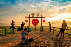
Mon Jam and the Highland Area
Mon Jam is a Thai domestic highland destination at roughly 1,300 meters, not just a viewpoint, and treating it as a 20-minute photo stop misses what it is. Thai tourists come here to camp at altitude, watch the stars, feed the sheep in the morning cold, eat strawberries at the farm stalls, and sit at the hilltop cafes with local coffee while the haze lifts from the valleys below. The developed infrastructure (panoramic cafe terraces, a camping ground, a jungle coaster, a zipline, rows of vendors) follows from that role.

The access road up is the part riders should plan for: it climbs steeply off the loop road in narrow, tightening bends, and the surface gets rougher and steeper near the top. Parking is informal, often on packed earth or gravel on a slope, so leave the bike pointing downhill and in gear. The viewpoint itself looks out over terraced farm plots dropping into the valley, the same plots that grow the strawberries and vegetables sold at the stalls.
Those farms are not decorative. The Nong Hoi Royal Project was established to replace opium cultivation with highland agriculture, and the strawberries, the arabica coffee, and the Japanese vegetables on the cafe menus grew out of that program. Knowing the farm stalls stand where opium fields used to changes how the place reads. The value is view-dependent: in clear air Mon Jam gives you a reason to stop and stay; in heavy smoke it is a cafe on a hill with little to see, which is worth knowing before you ride the climb for it.
Plan on 45 to 60 minutes minimum, and treat the cafe hours as unreliable. Morning is the best window: by midday some of the mountain cafes simply close on no schedule anyone outside can predict.
I once rode up to Mon Jam at noon to find seventy people on the terrace and a handwritten sign on the bamboo door: today we open at 5pm. No reason given. It happens often enough that if you are planning lunch at Mon Jam specifically, you need a backup in mind before you climb the hill, and the climb is steep enough that you do not want to ride it twice for nothing.
Baan Mon Muan
Baan Mon Muan, nearby at around 1,200 meters in a traditional wooden Lanna-style building, suits travelers who want a proper sit-down northern Thai meal with the view rather than farm-stall food. It has previously appeared in Michelin coverage, the menu runs northern Thai, and the baked pork ribs with lemongrass and local herbs are the signature, with produce from farms visible off the dining terrace. It is less relevant if you are happy with strawberries and noodles at the stalls and want to keep moving. This is a working boutique resort, so walk-in availability depends on how full the dining room already is. Check ahead before you build your lunch plan around it.
The Forest Road Toward Samoeng
The forest section after Mon Jam is quieter, narrower, and more riding-focused than Mae Sa Valley. Traffic drops away quickly once you clear the last tourist infrastructure, the road tightens but stays manageable, and for stretches you may be the only moving thing in either direction. Riders who come for the riding rather than the stops often find this the best part of the loop.
The character shift is structural, not accidental. Mae Sa Valley was built to serve resorts and nurseries; this stretch connects mountain communities to the valley, so there is less reason for it to be wide or busy. The surface is generally good but patchier than the valley road, with the occasional gravel wash or broken edge after rain, so it rewards reading the road a few corners ahead rather than just following the line.
Samoeng Town
Samoeng town sits about five kilometers off Route 1096 and is an optional detour, not part of the loop itself. Reaching it means a deliberate turn and the same five kilometers back. The town has local food, a morning market, and a fuel stop that is useful if you are running low after the no-petrol stretch.
Include it if you want a sit-down lunch and a look at what the Samoeng district actually is (an agricultural community organized around the winter strawberry season), or if you need fuel and food in a quieter setting than the valley. The loop is complete without it, and on a tight full-loop day the ten kilometers and the time they take are the first thing most riders cut. If you do add it, account for the detour in your day plan rather than treating it as a free stop.
Samoeng Forest Viewpoint

The Samoeng Forest Viewpoint is a free roadside pullout near the junction where the road splits toward Samoeng village, marked by a wooden sign. It is a simple shoulder with room for a handful of bikes, no fee and no infrastructure, looking out over ridgelines layered into the distance, the point on the loop where you first register how much height you have gained. It is easy to ride straight past, so watch for the sign after the Samoeng junction. Five minutes is enough for most riders, it works in any season the air is clear, and it adds almost nothing to the day.
Mae Sap Cave

Mae Sap Cave sits inside Khun Khan National Park and is worth the stop if caves interest you. Access, fees, and equipment requirements can change, so check with park staff before planning it as a stop; helmet and light equipment may be required or provided. A short path and steps lead from the parking area to the mouth; inside, the floor is uneven and damp and the ceiling drops low in places, so footing matters more than pace. The front chambers catch enough daylight to see by, but the deeper sections are dark, and there the formations shift color in a way that looks nothing like the landscape outside.
This is a stop for travelers who actively like caves; if you do not, it is an easy one to leave off without losing the character of the loop. Go in with at least one other person: networks this size are easy to get disoriented in, and rushing means you miss what you came for.
Route 1269: The Southern Return
Route 1269 is the serious riding section of the loop, with steep switchbacks in the Mae Khanin / Ban Mae Khanin area that demand deliberate line choices. This is the steepest road on the circuit and the one that rewards attention to the surface over the scenery. Ridden counterclockwise, you arrive here at the end of the day with hours of riding behind you; ridden clockwise, it is your first road, before you have settled into the bike.
This is the section the earlier warning about rider skill was about. Pick your line into each switchback early, use engine braking on the descents rather than dragging the brakes, and watch the surface through the tighter bends, where leaf litter and the odd patch of gravel collect on the inside of corners. The road asks for downhill braking control and the ability to hold a line through bends where you cannot see the exit, and it asks for it at the end of a long day, when your forearms are already tired and your concentration is harder to hold than it was at nine in the morning.
The thing that catches people out on 1269 is not the steepness, it is the light and the fatigue stacking up at the same time. The switchbacks on 1269 need clear markings and good sight lines, and once the sun drops behind the ridge they get hard fast, and by then your forearms are already tired from the day. I would rather start the whole loop an hour earlier than finish this road in low light with tired hands.
Returning after dark is a real increase in difficulty on the hardest part of the loop, not a minor inconvenience. Plan the day so you ride Route 1269 in daylight, ideally in the early to mid-afternoon when the light on the switchbacks is clear and readable.
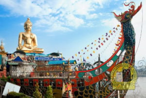
Wat Phra That Doi Kham

Wat Phra That Doi Kham sits on a hillock at the southern end of the loop, between Route 1269 and Chiang Mai, which makes it a natural final stop on a counterclockwise ride. A 17-meter golden stupa dominates the compound, surrounded by meditation halls with the layered brown roofs of northern Thai architecture, and a large seated Buddha faces the entrance. The hillside position gives a wide view over the southern Chiang Mai plain, the flatland around the airport spreading out below.
This is a working local temple far more than a tourist stop. Thai visitors come for the large Buddha image, which by repute grants wishes, and you will see strings of jasmine garlands left in thanks: that local devotion, rather than foreign tourism, is why it can be busy with Thai families when the foreign crowds are all on Doi Suthep. It suits riders who want a quiet final stop and a last view over the valley; if you have had your fill of temples earlier in the trip, it is an easy one to skip on the way in. Dress modestly. It adds 15 to 20 minutes and fits the return logic without needing a detour.
Sample Day Plan: How Start Time Changes the Loop
An 8:00 start is what makes the full loop work counterclockwise without rushing any stop. Here is how the day runs and how it falls apart when you leave later.
8:00 start (the loop works): Leave Chiang Mai at 8:00 and fill up on Route 107 before the Mae Rim junction. Reach Mae Sa Waterfall around 9:00, before the day-trippers crowd the lower pools, and walk the upper tiers in 30 to 45 minutes. Give Queen Sirikit Botanical Garden 45 to 90 minutes, then ride to Mon Jam and stay at least 45 to 60. Take Route 1269 south in the early-to-mid afternoon with clear light on the switchbacks, and return to Chiang Mai between 15:30 and 16:30.
9:00 start (margins shrink): Mae Sa and the garden together run 75 to 135 minutes before you add riding time between them, which puts you at Mon Jam after 13:00 and on Route 1269 well into the afternoon. The day still works, but you have lost your buffer: one slow cafe or one closed gate and you are choosing which stop to cut.
Late start (stops start falling off): Leave after 10:00 and the loop stops being a comfortable day. You either drop Mon Jam or the garden, or you finish Route 1269 close to dusk on the hardest road of the loop. At that point the honest move is to drop the full loop and ride Mae Sa Valley as an out-and-back, which is a good half-day on its own and keeps the difficult section out of low light.
The day breaks in predictable ways: treating Mon Jam as a 20-minute stop, adding Samoeng town without counting the detour, assuming the garden’s museum section is open on a Monday, and skipping the fuel stop on Route 107. Avoid those four and the timing looks after itself.
When to Ride the Samoeng Loop: Season and Weekends
The Samoeng Loop is at its best from November to mid-February: clear air, visible mountain views, cold mornings that make the elevation feel real, and strawberry season running in the highlands. If you are in Chiang Mai in that window, this is a ride worth building a day around.
Late February through April is smoky season, when farmers across the northern highlands burn fields after harvest and the smoke settles against the mountains. On bad days, common in March and April, the long views go flat or disappear. The road, the waterfall, and the cafes are all still there, and plenty of riders still enjoy the day for the riding, but the long mountain views are usually muted or gone. If those views are your main reason for the trip, another month is the better choice; if the riding itself is the draw, the loop still delivers.
I have ridden this loop in clear January air and in March haze, and the difference is not cosmetic. In January you can pick out individual ridgelines from Mon Jam, range behind range. In March the same terrace looks out on flat grey, the far hills simply not there, and your eyes sting by the second cafe. The road rides the same in both; the reason most people come does not survive the smoke.
Rainy season, June through October, leaves the road wet and can close sections behind fog that does not lift. The loop is rideable, but Route 1269 on slick pavement asks for real confidence cornering on wet surfaces and the right tyres, better saved until you already know the route in the dry. As for weekends: the Saturday and Sunday traffic on Mae Sa Valley is mostly Thai families in cars heading to the strawberry farms on Route 1096, moving slowly and keeping their lane, which means fewer overtaking chances on the curves rather than added danger. Around Mon Jam, weekend domestic crowds build through the morning, so arriving before 9:00 is the difference between sharing the view with a few people and competing for parking on that gravel slope.
Is the Full Samoeng Loop Worth It? Final Route Judgment
The full Samoeng Loop is worth doing on a clear-season day when you can start by 8:00 and ride all three sections in daylight: that is when the road, the views, and the stops all line up. The circuit rewards riders who plan around time, fuel, and light rather than following Google Maps and hoping. Get the season and the start time right, and few day rides this close to Chiang Mai give you this much variety in a hundred kilometers.
When those conditions are not there, the Mae Sa Valley out-and-back is the smarter ride: a comfortable half day on the easiest section, with no pressure on the light or the switchbacks. The loop is not going anywhere: coming back with a clear morning and an early start gets you far more out of it than forcing it on a late start in March haze.
For a longer multi-day ride in the same spirit, the Mae Hong Son Loop and the Nan Loop cover bigger mountain country east and west of here.